


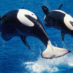


On a rare, clear day, one can look due west from the Mount Wilson Observatory, perched at nearly 6,000 feet on the outskirts of Los Angeles, and see the wide basin of the San Fernando Valley. A natural bowl flanked by mountains, the valley floor once teemed with life, as foxes, hares, deer, and coyotes coursed through its trough, occasionally plucked by skulking cougars, also known as mountain lions.
For much of that time, this valley also served as a primary transit corridor for the Chumash people, who traveled between inland fields and the coast to gather acorns and seeds, as well as to trade with the Tongva and other tribes. As in so many places, the trails these tribes followed were largely based on the tracks of elk and other nonhuman animals, who had already discovered the most efficient routes from place to place.
The accompanying article is excerpted and adapted from “The Hidden Nations of Animals: A Grand Tour of Earth’s Wild Civilizations,” by Ryan Huling. Illustrated by Oliver Uberti. (Avery Books, 288 pages.)
When Spanish colonists arrived in the 18th century, they, too, exploited many of these well-established human-animal paths, redesignating trodden dirt as the southern leg of what they christened El Camino Real — the Royal Road. Often referred to as California’s first highway, it connected 21 Franciscan missions from San Diego to Sonoma and formed the spine of what would later become the 101 freeway, a 10-lane wall of speeding steel that bisected the southwest corner of the valley and obliterated its natural land-bridge. When that concrete river and its tributaries were poured, it fragmented a Pangean region and marooned animal populations on an archipelago of newly birthed terrestrial islands.
Without a viable path across one of the busiest roadways in the country, the cougar population trapped on the south side of the 101, in the Santa Monica Mountains, now has among the lowest genetic diversity ever recorded for the species — a result of unavoidable inbreeding between brother and sister, or parent and child, triggering what researchers call an “extinction vortex.”
Perhaps desperate to break the cycle, some intrepid individuals make foolhardy attempts to leap between the earthen isles by sprinting across the freeway. One cool, late-spring morning, under cover of the marine layer, a young, unidentified cougar tried to cross the divide, but didn’t get far. At 4:48 a.m., the California Highway Patrol received a call about a deceased animal in the southernmost lane, near the intersection with Liberty Canyon Road.
When I heard the news, all I could think was, “If only he’d held out a little bit longer.” I had, in fact, made several recent visits to that exact intersection, so I instantly understood why it was the one the cougar chose. It’s the region’s only remaining patch of highway with enough protected space on both its north and south slopes to facilitate a discreet approach to the road’s edge, and countless animals have been photographed in the same spot as they look longingly to the other side.
The cougar population trapped on the south side of the 101, in the Santa Monica Mountains, now has among the lowest genetic diversity ever recorded for the species
From the hills to the north, cougars can glimpse the expansive Santa Monica Mountains, one of only two “biodiversity hotspots” left in the continental United States. Under a business-as-usual scenario, the looming extinction vortex could leave those mountains completely cougar-free within 15 years.
From atop the Phantom Trail, which skirts the steep hills along the freeway’s south side, hikers are rewarded with a transfixing view of the Simi Hills and Santa Susana Mountains. Beyond them, the 2,700 square miles of Los Padres National Forest beckon.
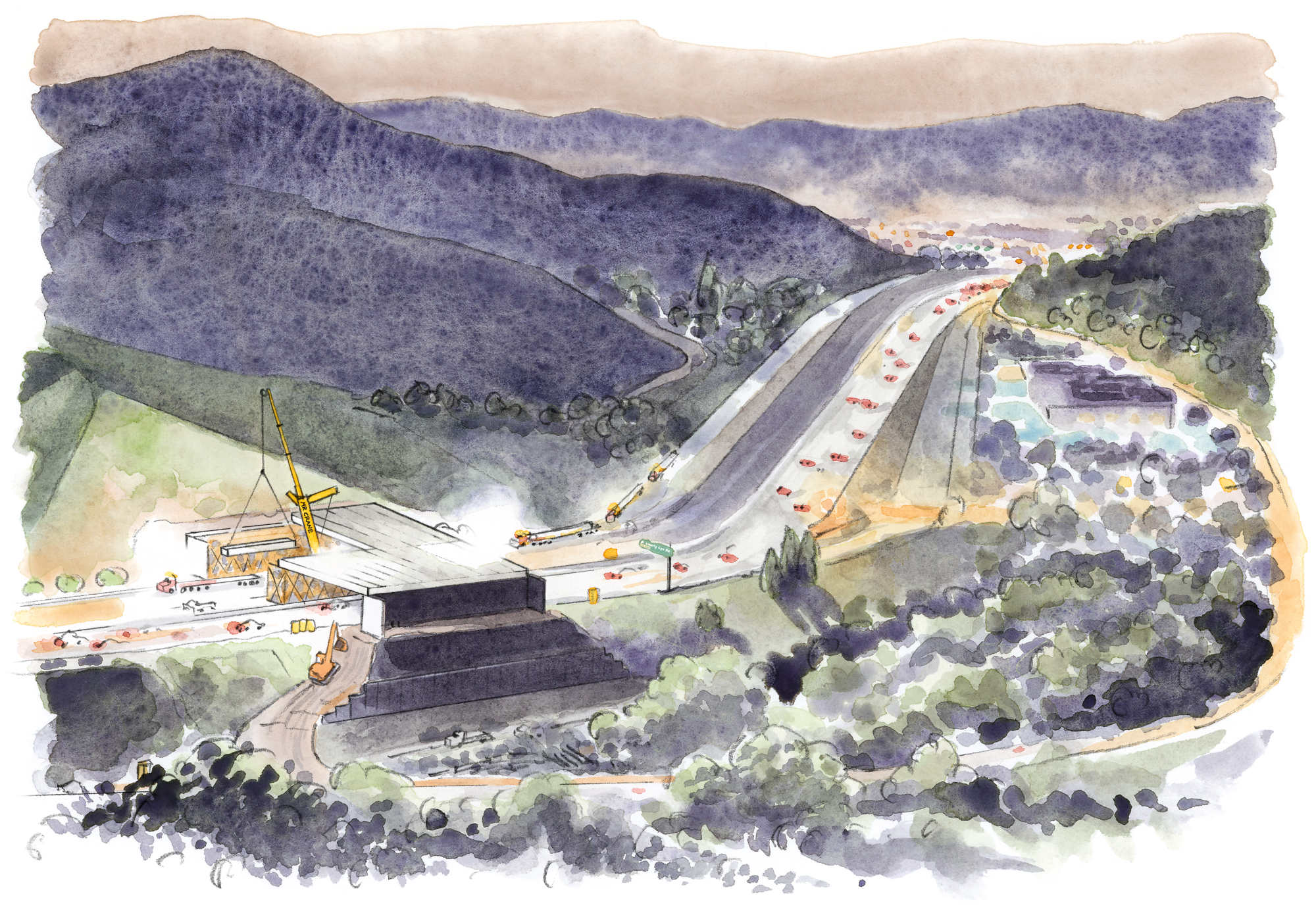
During one of my nighttime visits to the trail, phantasmal silhouettes darted through nearby bushes as midnight approached, illuminated ever so slightly by large spotlights down on the road. Then, at precisely 11:36 p.m., I watched as northbound traffic was abruptly rerouted onto an adjacent access road and thundering tire rumbles were temporarily replaced by the gentle beeps of concrete mixers and construction cranes lowering girders into place.
I was drawn to this particular intersection because since 2022, it’s been undergoing an expansion, but not to build more lanes or on-ramps. Not in the traditional sense, anyway. In fact, once it’s done this December, the new addition won’t be paved at all. Rather, it will be landscaped with a football field’s worth of coastal sage scrub, toyon, native grapes, sunflowers, and dozens of other native plants.
Once those transplanted roots dig in, Liberty Canyon will be home to what organizers say is the largest wildlife crossing anywhere in the world. A mammoth 210-foot “vegetated bridge” that will, at least at this one critical choke point, seek to restore a natural link relied upon for millennia by not only mountain lions, but also coyotes, bobcats, birds, frogs, butterflies, and lizards.
Returning to the area for the first time since the nameless young cougar met his demise, I arranged to join Jewlya Samaniego, an ethnobotanist of Chumash and Tataviam ancestry, for a tour of the purpose-built nursery she helps maintain a few miles away from the construction site. Inside, she showed off some of the 6,000 plants she was growing as part of phase 1 of the project, all of which were cultivated from seeds foraged within a seven-mile radius. By the end of 2025, she planned to relocate them all to the crossing site and start fresh with another 40,000 plants as part of phase 2, which includes the on-ramps that connect the crossing to the adjacent hillsides. Once the phase 2 plants are installed, her job is complete and nature takes it from there.
If her efforts are successful, Samaniego said, the crossing structure will be so seamlessly integrated into the hills that it will “seem like it was always there.” A space reinvigorated by the same thick greenery that graced this place when her ancestors foraged across it centuries earlier.
The wildlife crossing, she believes, is a good-faith attempt by humanity to leverage ecosystem engineering to turn back the clock, deconflict our earlier intrusions, and acknowledge that this place has always been a vital crossroads for far more than one species. A tangible affirmation of the sovereignty of animal nations.
The mammoth 210-foot “vegetated bridge” will, at least at this one critical choke point, seek to restore a natural link relied upon for millennia by not only mountain lions, but also coyotes, bobcats, birds, frogs, butterflies, and lizards.
Unwinding the impacts of one of the world’s busiest highways is no easy feat. More than 300,000 cars pass through Liberty Canyon every day, according to Lauren Gill, a deputy director of the National Wildlife Federation, or NWF. That congestion creates extensive noise and light pollution, meaning the new crossing will need soundproof walls to reassure animals that it’s safe to pass. All told, this “ecological stitch” will require more than 2,700 tons of steel and 39,000 tons of concrete to once again knit together two biological communities. There is also a plan to build a separate viewing platform on the hillside overlooking the crossing, in response to intense public curiosity.
But for Samaniego, completion of the project carries a higher significance. In the Chumash tradition, the first people on Earth were believed to possess both human and nonhuman traits. That all changed when a great flood swept across the land, prompting many people to transmute into a fully animal form to survive. To this day, Chumash folktales often begin with “When the animals were people …”
Many of those “animal relatives,” she believes, carry the wisdom of her elders. Coyotes, for example, are revered for their cleverness. Raccoons are viewed as mentors who teach young people about which local plants are edible. In a very real sense, she says, by allowing wild animals to move freely again, the crossing and the tracking data that underpins it enable us to “listen to the animals and hear what they have to say.”
The Liberty Canyon crossing is the boldest entry yet in a raft of projects that seek to reverse disruptions inadvertently created while building our own infrastructure.
Just 20 minutes farther up the road, Gill from NWF showed me around the Conejo Grade, where the 101 tumbles down from the mountains and onward to the coast. GPS tracking and camera-trap data obtained by the National Park Service show that cougars, gray foxes, bobcats, mule deer, and other animals will often walk right up to the highway at this point, she said, but rarely attempt to cross it due to the near certainty of being struck by a car. It’s one of hundreds of locations NWF and its partners have identified where vegetated bridges and other crossings could reconnect wildlife communities across the state. If their efforts are successful, a cougar could theoretically travel from the Southern California coast to the Sierra Nevada — hundreds of miles to the northeast — without touching concrete once.
Vegetated bridges serve as multifunctional spaces used by all sorts of animals, but sometimes crossings are designed with highly specific users in mind. In Central California’s Sonora Pass, advocates identified an ideal place to insert a slatted steel grate into State Route 108, which now allows toads to successfully cross the road just inches below the rolling tires overhead. Up in wine country, NWF plans to build a crossing for the thousands of newts whose migration out of a rural lake was interrupted by Chileno Valley Road. As a temporary measure until construction is completed, newts have been hand carried across the road in buckets by a group of volunteers calling themselves the Chileno Valley Newt Brigade.

In some cases, facilitating such reconnections requires only minimal investment and the simplest of constructions. On a visit to an underpass below the 118 freeway, Gill showed me how the decades-old road had been intentionally built with a drainage culvert to allow rainfall to flow underneath it. Unfortunately, this drainage included a 10-foot vertical concrete cliff, which works fine for water, but amounts to a death drop for wildlife. Camera traps affixed to the underside of the road documented only eight detections of animals utilizing the drainage, most of which were raccoon families who carefully pawed their way down a nearby maintenance ladder. But after discussions with NWF, the California Department of Transportation added a simple concrete ramp, which transformed the drop-off into a gradual slope. Once it was added, the same cameras captured more than a thousand wildlife uses, not only by grateful raccoons, but also by coyotes, skunks, and at least one black bear. Total cost of the ramp? About $12,000.
Studies show that animals will go to extraordinary lengths to avoid the perils of our highways, often making early attempts to utilize wildlife crossings before they’re even finished. Once construction of an overpass or underpass is completed, it can reduce animal-vehicle collisions by up to 97 percent.
In Utah, more than seven hundred animals now trot over a high-elevation wildlife crossing that spans I-80 each year, including moose, bears, and porcupines. In 2024, Colorado opened the first in a series of wildlife overpasses and underpasses just west of Denver, which provide reliable routes for elk and bobcats. Across the Mountain West, bighorn sheep, pikas, coyotes, pronghorn antelope, and many other native animals are suddenly returning to areas they had been unexpectedly cut off from. Along the Columbia River in Oregon and Washington, a system of fish ladders enables salmon — who sometimes travel up to a thousand miles to feed in the open ocean before returning at the end of their lives to the exact rivers where they were born — to bypass upstream disruptions created by human dams.

Similar stories are playing out around the world. In Belgium, a bridge spans Brussels Ring Road to facilitate free transit between the surrounding forests by foxes, amphibians, and even insects. Wild boars in Germany, lynxes in the Czech Republic, red squirrels in the U.K., tigers in India, koalas and possums in Australia, and macaques in Singapore have all benefited from specially built structures that empower them to get where they need to go. In perhaps the most striking example of all, a steel bridge over Murray Road on Christmas Island in the Indian Ocean — human population: 2,000 — allows safe passage for millions of red crabs to get from the forest to the ocean.
The proliferation of such benevolent structures stands as proof that, when we want to, we can do great things. They send an intelligible but soft-spoken message from humanity to the rest of the animal kingdom that says, “We see you.”
Ryan Huling is an explorer and sustainable food systems specialist based in Sierra Madre, California. He is currently a senior writer at the Good Food Institute Asia Pacific. His columns have appeared in Nature, Wired, National Geographic, the Los Angeles Times, TIME, USA Today, The Nikkei, and the South China Morning Post.
Oliver Uberti is a former senior design editor for National Geographic and the coauthor of three critically acclaimed books of maps and graphics: “Atlas of the Invisible,” “Where the Animals Go,” and “London: The Information Capital,” each of which won the top British Cartographic Society Award for cartographic excellence. He lives in Los Angeles, California.
Pretty! This has been a really wonderful post. Many thanks for providing these details.