


Below Aging U.S. Dams, a Potential Toxic Calamity
A multimedia version of this story, with rich maps and data, is available here.
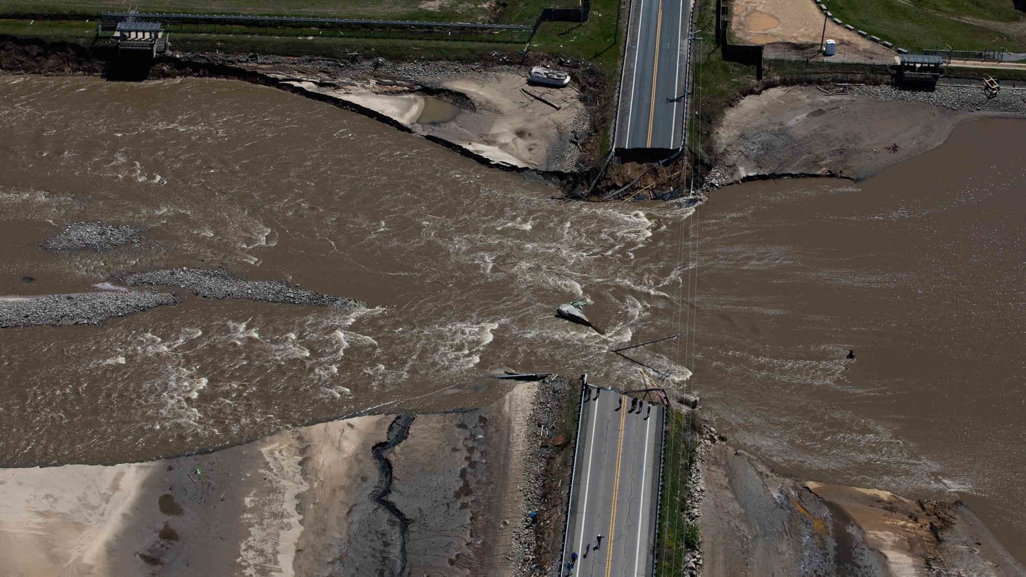
On May 19, 2020, a group of engineers and emergency officials gathered at a fire station in Edenville, Michigan to decide what to do about the Edenville Dam, a 97-year-old hydroelectric structure about a mile upstream on the Tittabawassee River. Over the preceding two days, heavy rains had swelled the river, filling the reservoir to its brim and overwhelming the dam’s spillway. The group was just about to discuss next steps when the radios went off, recalled Roger Dufresne, Edenville Township’s longtime fire chief. “That’s when the dam broke.”
“Up at the dam, Edenville residents watched as a portion of the eastern embankment liquified. Muddy water gushed through the breach. Over the next few minutes, that water became a torrent, snapping trees and telephone poles as it rushed past town, nearly submerging entire houses further downstream.
Onlookers recorded the failure of the Edenville Dam in May of last year. Visual: MLive
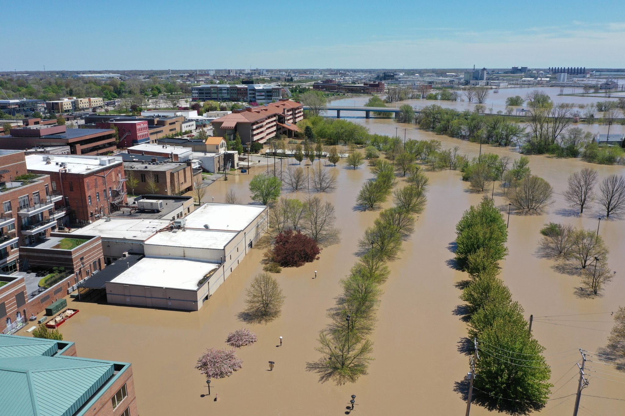
About 10 miles and two hours later, the flood wave bowled into a second aging dam, damaging its spillway, overtopping, and then breaching the embankment.
Al Taylor, then chief of the hazardous waste section within the state’s Department of Environment, Great Lakes, and Energy, was following the situation closely as the surge swept 10 miles further downstream into the larger city of Midland, where it caused a Dow Chemical Company plant flanking the river to shut down, and threatened to mix with the plant’s containment ponds. Taylor, who retired at the end of January, worried that contamination from the ponds would spill into the river. But that was just the first of his concerns.
In prior decades, Dow had dumped dioxin-laden waste from the plant directly into the river, contaminating more than 50 miles of sediment downstream — through the Tittabawassee, the Saginaw River, and the Saginaw Bay — with carcinogenic material. The contamination was so severe that the U.S. Environmental Protection Agency stepped in, and since 2012, worked with Dow to map and cap the contaminated sediments. In designing the cleanup, engineers accounted for the river’s frequent flooding, Taylor knew, but nobody had planned for the specific impacts of flooding caused by a dam failure.
While the dramatic breach of the Edenville Dam captured national headlines, an Undark investigation has identified 81 other dams in 24 states, that, if they were to fail, could flood a major toxic waste site and potentially spread contaminated material into surrounding communities.
In interviews with dam safety, environmental, and emergency officials, Undark also found that, as in Michigan, the risks these dams pose to toxic waste sites are largely unrecognized by any agency, leaving communities across the country vulnerable to the same kind of low-probability, but high-consequence disaster that played out in Midland.
After the flooding subsided, Dow and state officials inspected the chemical plant’s containment ponds and found that, though one of the brine ponds containing contaminated sediment had been breached, there was no evidence of significant toxic release. Preliminary sediment samples taken downstream did not find any new contamination. The plant’s and the cleanup’s engineering, it seemed, had done its job.
“Dow has well-developed, comprehensive emergency preparedness plans in place at our sites around the world,” Kyle Bandlow, Dow’s corporate media relations director, wrote in an email to Undark. “The breadth and depth of these plans — and our ability to quickly mobilize them –– enabled the safety of our colleagues and our community during this historic flood event.”
But things could have gone differently — if not in Midland, then somewhere else with a toxic waste site downstream of an aging dam less prepared for a flood. “As a lesson learned from this,” Taylor said, “we need to be aware of that possibility.”
In the United States, there are more than 90,000 dams providing flood control, power generation, water supplies, and other critical services, according to the National Inventory of Dams database maintained by the U.S. Army Corps of Engineers, which includes both behemoths like the Hoover Dam and small dams holding back irrigation ponds. Structural and safety oversight of these dams falls under a loose and, critics say, inadequate patchwork of state and federal remit.
A 2019 report from the Congressional Research Service (CRS), the nonpartisan research arm of the U.S. Congress, found roughly 3 percent of the nation’s dams are federally owned, including some of the country’s largest, with the rest owned and operated by public utilities, state and local governments, and private owners. The report estimated that half of all dams were over 50 years old, including many that were built to now obsolete safety standards. About 15 percent of dams in the Army Corps database lacked data on when they were built.
In addition to information on age and design, the Army Corps database includes a “hazard potential” used to describe the possible impact of a dam failure to life and property. In 2019, roughly 17 percent, or 15,629 dams, had a high hazard potential rating, indicating that a loss of human life was likely in the event of a dam failure. The number of high-hazard dams has increased in recent years due to new downstream development.
According to the CRS report, more than 2,300 dams in the database were both high-hazard and in “poor” or “unsatisfactory” condition during their most recent inspection. Due to security concerns that arose after the September 11 terrorist attacks, the report did not name these dams, though an investigation by The Associated Press in 2019 identified nearly 1,700 of them.
For all that is known about America’s aging dam infrastructure, however, little information exists about the particular hazards dams pose to toxic waste sites downstream. This is why regulators knew about problems with the Edenville Dam and knew about the Dow cleanup, but had not connected the dots.
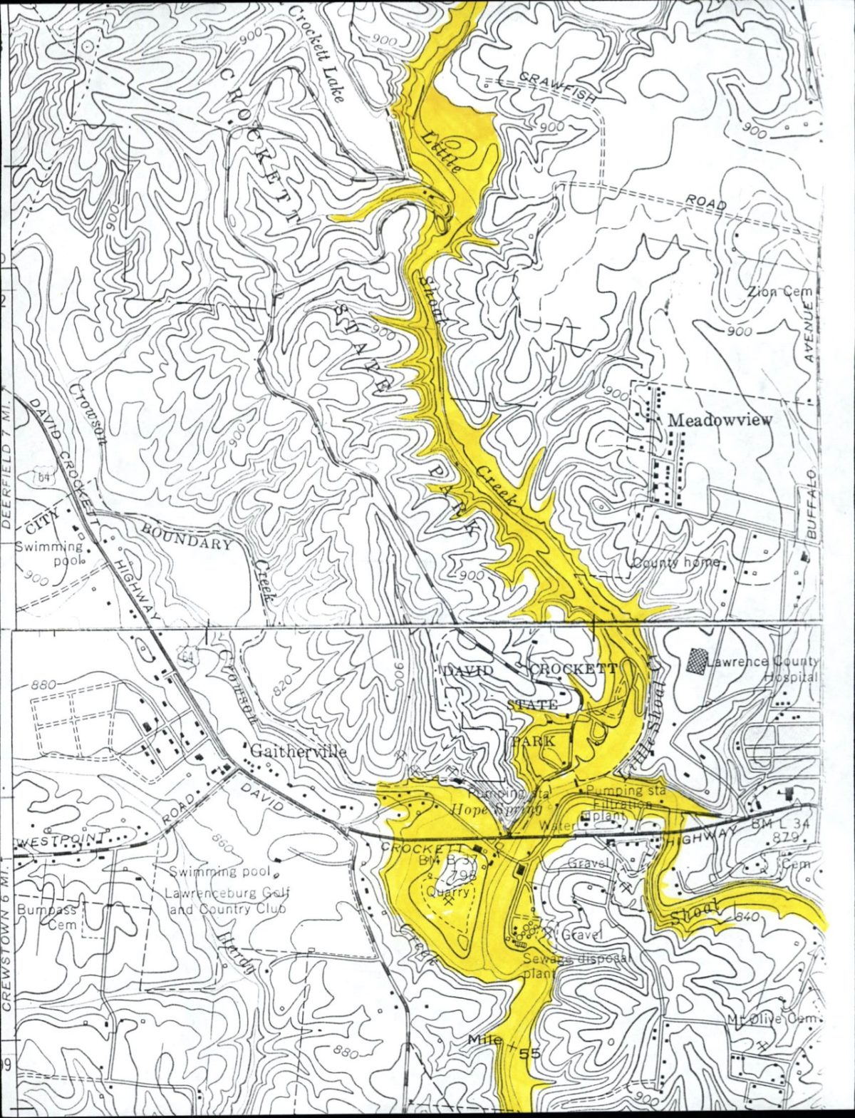
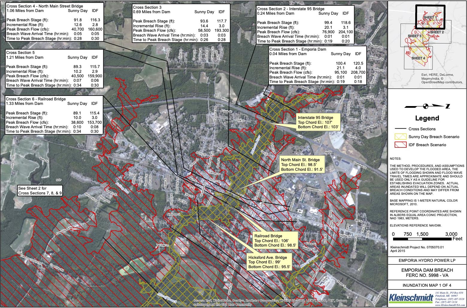
Inundation maps model the area that would likely be flooded in a dam failure scenario.
Visual: Tennessee Department of Environment and Conservation
To identify dams that might pose the most serious risk to toxic waste sites, Undark searched for dams in the national database that are both high-hazard and older than 50 years, the age after which many dams require renovations. To narrow our search, we selected dams that sit 6 or fewer miles away from and appear in satellite images to be upstream of an EPA-listed toxic waste site. Experts say that many dams would flood much farther than 6 miles.
We then filed requests under state and federal freedom of information laws with various agencies, including the Federal Energy Regulatory Commission, seeking dam inspection reports and the Emergency Action Plans (EAPs) that dam owners are typically required to prepare and maintain. Among other things, these plans usually include inundation maps, which model the area that would likely be flooded in a dam failure scenario.
The inputs for these models vary by state, and while some inundation maps were highly sophisticated, involving contingencies for weather and other variables, others were less so. In one Emergency Action Plan for a dam in Tennessee, the inundation zone was simply hand-drawn on a map with a highlighter (see above image). But whatever their quality, the maps represent dam officials’ best estimate of where large volumes of water will flow if a dam fails.
Undark successfully obtained inundation modeling information for 153 of the 259 dams identified in our search. For 63 dams, state and federal officials declined to provide or otherwise redacted pertinent inundation information, citing security concerns. For 31 dams, agencies said they did not have inundation maps prepared, or provided maps that were illegible or did not extend to the site. Despite improvement in recent years, about 19 percent of high-hazard dams still lacked plans as of 2018, according to the American Society of Civil Engineers.
With those maps, we then looked to see if any EPA-listed toxic waste sites fell within the delineated inundation areas. Because the precise boundaries of each toxic waste site are not consistently available, we followed the methodology of a 2019 Government Accountability Office analysis of flood risks to contaminated sites on the EPA’s National Priorities List — more commonly known as Superfund sites — which used a 0.2-mile radius around the coordinates listed by the EPA for each location.
For a number of dams for which we were not able to obtain inundation maps to review ourselves, dam regulators or owners confirmed that coordinates we provided for the toxic waste site fell within 0.2 miles of the dam’s inundation zone.
We focused our search on the nation’s highest priority cleanup sites, as indicated by a designation of Superfund (for non-operating sites) or RCRA (Resource Conservation and Recovery Act of 1976, for operating sites). We considered 5,695 of these sites, including both current and former sites. Types and levels of contamination vary widely across sites, as would the impact of any flooding.
Using this methodology, we identified at least 81 aging high-hazard dams that could flood portions of at least one toxic waste site if they failed, potentially spreading contaminated material into surrounding communities and exposing hundreds or thousands of people — in the case of very large dams, many more — to health hazards atop significant environmental impacts. At least six of the dams identified were in “poor” or “unsafe” condition during their most recent inspection.
In many instances, state and local agencies responsible for dam safety and toxic waste have not accounted for this kind of cascading disaster, and so remain largely unprepared.
Undark shared this analysis with engineering and dam safety experts, who verified the methodology. Several suggested that the true number of dams that could flood toxic waste sites if they were to fail is almost certainly far greater, but because no agency tracks this particular hazard, the actual number remains unknown.
“There are many situations across the country then with these dams where they don’t meet the current safety standards …” said Mark Ogden, a civil engineer who reviewed the American Society of Civil Engineer’s 2021 Infrastructure Report Card section on dams, which gave U.S. dams a “D” grade. “And the fact that there could be these hazardous sites as part of that, just increases that concern and what the consequences of a failure might be.”
Though impacts would vary widely, environmental scientists and toxicologists interviewed by Undark suggested that a sudden, intense flood caused by a dam failure could spread contaminants from hazardous waste sites into surrounding communities. Even sites designed to withstand flooding might be impacted if the debris carried in floodwater managed to scour and erode protective caps, potentially releasing toxic material into the water, explained Rick Rediske, a toxicologist at Grand Valley State University in Michigan. In Houston in 2017, flooding from Hurricane Harvey eroded a temporary protective cap at the San Jacinto River Waste Pits Superfund site, exposing dioxins and other toxic substances.
Water could then move contaminants around the site and redeposit them anywhere in the floodplain, exposing people and ecosystems to health hazards, said Jacob Carter, a research scientist at the Union of Concerned Scientists, who formerly studied flooding hazards to contaminated sites for the EPA. Carter also pointed out that communities living nearest to toxic waste sites and so most vulnerable to these events tend to be low income and communities of color.
It’s possible that any toxic material would be diluted by the flood and new clean sediment, said Allen Burton, director of the Institute for Global Change Biology at the University of Michigan. But this, he emphasized, would be a best-case scenario.
Generally, when there’s a massive flood like the one in Michigan, “it just moves the sediment everywhere downstream,” said Burton. “You have no way of predicting, really, how much of the bad stuff moved, how far it moved, how far it got out into the floodplain, what the concentrations are.” And regulated waste sites are just one source of potential contamination in a dam breach scenario, said Burton. Sediment behind dams is itself often contaminated after years of collecting whatever went into the river upstream.
Contamination can also come from more mundane sources in the floodplain, like wastewater treatment plants or the oil canisters in people’s basements that get swept into floodwaters, said Burton. “The fish downstream,” he quipped, “don’t care if contaminants came from your garage or Dow Chemical.”
Undark’s investigation found that state and local governments often have not prepared for the flooding that could occur at toxic waste sites in the event of a dam failure.
Emporia Foundry Incorporated, a federally-regulated hazardous waste site in Greensville County, Virginia, provides a representative example. It falls within the inundation zone of the 113-year-old Emporia Dam, which is a hydroelectric dam partially owned by the city and located on the Meherrin River, just over one mile west of the foundry site.”
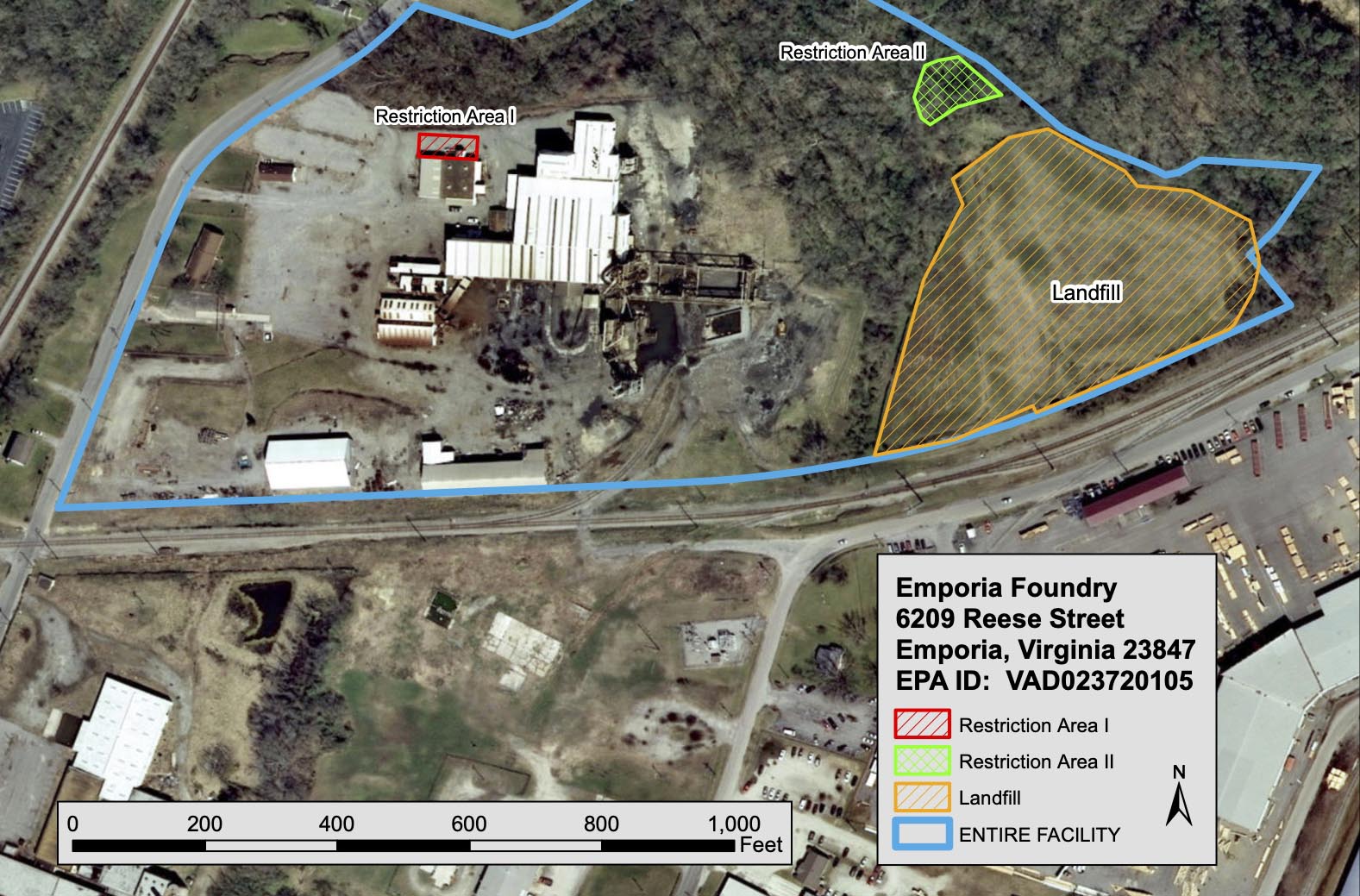
The foundry, which once manufactured manhole covers and drain grates, includes a landfill packed with byproducts containing lead, arsenic, and cadmium. The landfill was capped in 1984, and in 2014, a second cap was added nearer to the river as a buffer against flooding. As in Midland, cleanup engineers accounted for flooding within the 100-year floodplain, but according to a spokesperson from the Virginia Department of Environmental Quality, they did not account for flooding from a dam failure.
The Emporia Dam inundation map shows that if the dam were to fail during a severe storm, the entire foundry site could be flooded, potentially disintegrating the cap and spreading contaminants across the floodplain. However, the site would not be flooded in the event of a “sunny day” failure.
More than 3,000 people live within a mile of the Emporia Foundry site, around 75 percent of whom are Black, according to EPA and 2010 census data.
Wendy C. Howard Cooper, director of Virginia’s dam safety program, explained that her program’s mandate is to define a dam’s inundation zone and inform local emergency managers of any immediate risks to human life and property — not to identify toxic waste sites and analyze what might happen to them during a flood. “That would be a rabbit hole that no one could regulate,” Howard Cooper said. She added that local governments should be familiar with both the dams and the contaminated sites inside their borders and should have proper emergency procedures in place.
This turned out not to be true in Greensville County, where the program coordinator for emergency services, J. Reggie Owens, told Undark he was unaware of the potential for the foundry site to flood if the Emporia Dam were to fail. The site is “not even in the floodplain,” he said. “It’s never been put on my radar by DEQ or anyone else.”
The Forestdale Pond Dam was considered “unsafe.”
Visual: EPA
A similar pattern emerged in other states. In Rhode Island, for instance, our search identified eight dams. One of these, the 138-year-old Forestdale Pond Dam, was considered “unsafe” during its most recent inspection.
Located in the town of North Smithfield, the dam is immediately adjacent to the Stamina Mills Superfund site, which once housed a textile mill that spilled the toxic solvent trichloroethylene into the soil. Another area on the site was used as a landfill for polycyclic aromatic hydrocarbons, sulfuric acid, soda ash, wool oil, plasticizers, and pesticides.
A few years after trichloroethylene was detected in groundwater in 1979, the site received a Superfund designation from the EPA. According to the federal agency, construction for the site cleanup — which involved removing the contaminated soil from the landfill and installing a groundwater treatment system — was completed in 2000 and accounted for a 100-year flood, but it did not account for flooding due to a dam failure.
According to EPA and census data, more than 2,500 people lived within a mile of Stamina Mills as of 2010, and Forestdale Pond is not the only dam that could pose a threat.
In fact, the site sits within the inundation zones of two other high hazard dams identified by Undark. A failure of either of these dams on the Slatersville Reservoir could cause a domino effect of dam failures downstream, according to Rhode Island dam safety reports, all leading to flooding at Stamina Mills.
When asked to comment on possible flood risks to the Superfund site, the EPA responded that the only remaining remedy at Stamina Mills, the groundwater treatment system, would not be affected if Forestdale Pond Dam were to fail. EPA made no reference to the larger Slatersville Reservoir dams less than two miles upstream.
Spokespersons at the Rhode Island dam safety office and the state office responsible for hazardous waste had not considered that a dam failure could flood any of the sites identified by Undark, including Stamina Mills.
By building engineered structures or taking other resiliency measures, the most hazardous waste sites can be designed to withstand flooding, explained Carter, who recently co-authored a report on climate change and coastal flooding hazards to Superfund sites. But in order to prepare for floods, Carter said, flooding hazards have to be recognized first, whether they come from rising seas, increasing storm surge, or, as in these cases, dams.
“They could have looked at that dam and said, ‘Oh, it gets a D minus for infrastructure. This thing could break,’” said Burton, referring to the Edenville Dam. “So in the future, it would be smart of EPA to require the principal party who’s responsible for the cleanup to look at the situation to see if it actually could happen.”
One step that could make that process much easier is for dam inundation zones to be regularly included in FEMA’s publicly available flood risk maps, which show the 100-year floodplain and other flood risks to communities, said Ogden. A lack of available data on dam inundations — sometimes the result of security concerns — presents a major obstacle, said a FEMA spokesperson, but plotting inundation zones on commonly-used flood risk maps would ensure communities and agencies are aware of and can respond to dam hazards.
Some states, including Rhode Island, have already made inundation zones, Emergency Action Plans, and inspection reports for the dams they regulate publicly available online. In South Carolina, following a 2015 event when heavy rains caused 50 dams to fail, dam inundations for the most hazardous state-regulated dams were made publicly available. Though no state agency tracks hazardous waste sites within dam inundation zones, Undark was able to identify three dams in South Carolina which could flood a hazardous waste site in the state using this resource.
In California, inundation zones for the state’s most hazardous dams were made available following a 2017 dam failure scare at the Oroville Dam, the tallest dam in the country, which led to the evacuation of more than 180,000 people.
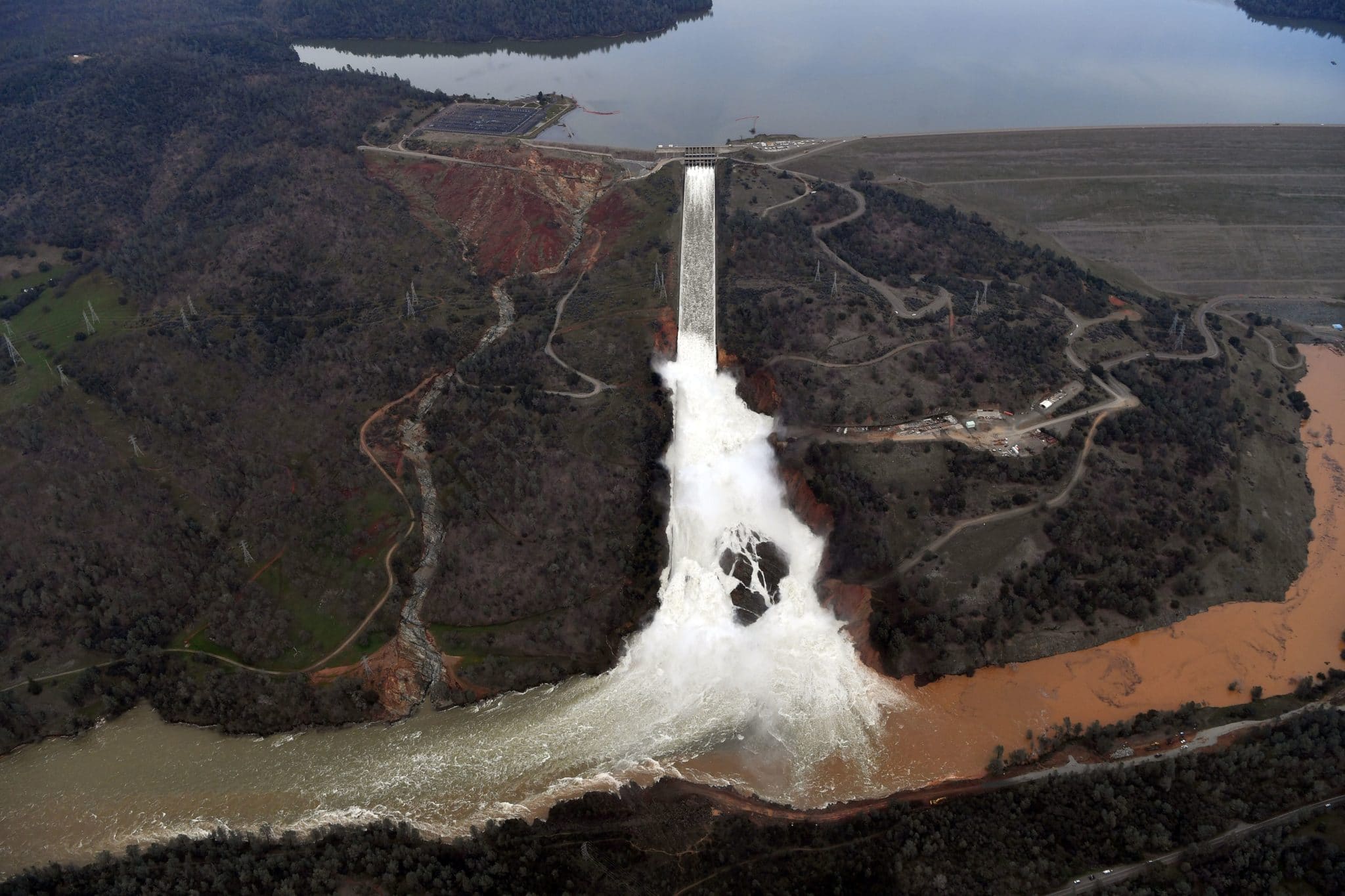
Using this resource, Undark identified four dams which would flood at least one hazardous waste site in California. These included the Oroville Dam, which could flood at least one current and one former Superfund site if it were to fail.
According to the EPA, neither of those sites downstream of the Oroville Dam had considered the possibility of flooding due to dam failure prior to the failure scare. Even so, commented EPA, due to the “extraordinary volume of water” that would flood the sites if the Oroville Dam were to fail, “it is not feasible to alter the existing landfills and groundwater remedy infrastructure to protect against the potential failure of the Oroville Dam.”
In order to fix the nation’s dams, the first step is to spread awareness about the importance of dams and the hazards they pose to people and property, said Farshid Vahedifard, a civil engineer at Mississippi State University who co-authored a recent letter in Science on the need to proactively address problematic dams. “The second thing is definitely we need to invest more.”
According to the Association of State Dam Safety Officials, the fixes necessary to rehabilitate all the nation’s dams would cost more than $64 billion; rehabilitating only the high hazard dams would cost around $22 billion. Meanwhile, the $10 million appropriated by Congress in 2020 for FEMA’s high hazard dam rehabilitation program are “kind of a drop in the bucket for what’s really needed,” said Ogden.
Indeed, state dam safety programs report a chronic lack of funds for dam safety projects, both from public sources and from private dam owners unable or unwilling to pay for expensive repairs. In Michigan, both dams that failed were operated by a company called Boyce Hydro, which received years of warnings from dam safety regulators that there were deficiencies.
Lee Mueller, Boyce Hydro’s co-manager, told Undark that the company made numerous improvements to the dams over the years. After losing revenue when the Federal Energy Regulatory Commission (FERC) revoked the company’s hydroelectric permit, however, it was unable to fund repairs that might have prevented the dam failures.
“Regarding the Edenville Dam breach, the subject of the State of Michigan’s governance and political policy failures and the insouciance of the environmental regulatory agencies are the subject of on-going litigation and will be more thoroughly detailed in the course of those legal proceedings,” Mueller wrote in an email.
“The state of Michigan knew about this,” said Dufresne, the Edenville fire chief. State regulators, he says, should have insisted that the company pay for the badly needed repairs. “They needed to push him,” said Dufresne, referring to Mueller. More than half of all dams in the U.S. are privately owned.
Without the funding to match the problem, members of the state dam safety community have looked to non-typical sources of funding, says Bill McCormick, chief of the Colorado dam safety program. In Eastern Oregon for example, the 90-year old Wallowa Lake Dam — which Undark found would flood the former Joseph Forest Products Superfund site if it were to fail — was slated last year for a $16 million renovation to repair its deteriorating spillway and add facilities for fish to pass through. But the plans have stalled since the Covid-19 pandemic has reduced Oregon’s lottery revenues, which were funding most of the project.
The challenges facing U.S. dams are also exacerbated by climate change, say dam safety experts, with more frequent extreme weather events and more intense flooding expected in parts of the country adding new stresses to old designs. “If we start getting much bigger storms, then that itself will lead to a higher probability of overtopping and dam failure,” said Upmanu Lall, director of the Columbia Water Center at Columbia University and co-author of a recent report on potential economic impacts of climate-induced dam failure, which considered how the presence of hazardous waste sites might further amplify damages. The report also outlines how in addition to more extreme weather, factors like changes in land use, sediment buildup, and changing frequencies of wet-dry and freeze-thaw cycles all can contribute to a higher probability of dam failure.
Several state dam safety programs contacted by Undark said they are planning for climate change-related impacts to dam infrastructure, though according McCormick, the Colorado dam safety chief, his state is the only one with dam safety rules which explicitly account for climate change. New rules that took effect in January require dam designs “to account for expected increases in temperature and associated increases in atmospheric moisture.”
“We were the first state to take that step, but I wouldn’t be surprised if others follow that lead,” McCormick said.
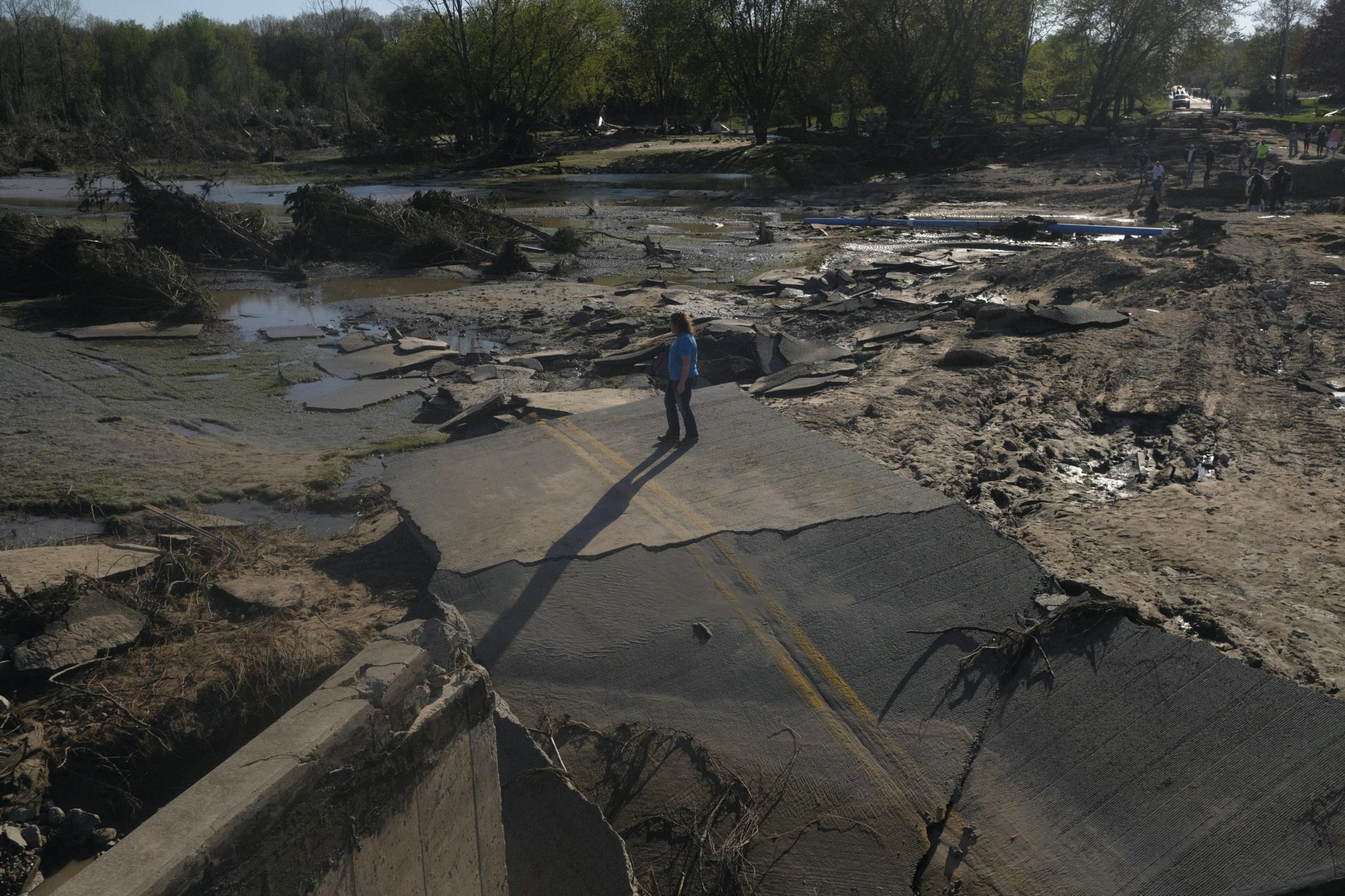
No deaths were reported in the Michigan flooding, but more than 10,000 residents had to be evacuated from their homes and the disaster likely caused more than $200 million in damage to surrounding property, according to a report from the office of Michigan Gov. Gretchen Whitmer. Restoring the empty reservoirs, as well as rebuilding the two dams, could cost upwards of $300 million, according to the Four Lakes Task Force, an organization that had been poised to buy the dams just before they failed.
In contrast, the Four Lakes Task Force, which now owns the dams, planned to spend about $35 million to acquire and repair those dams and an additional two dams prior to the breach. Boyce Hydro declared bankruptcy in July and now faces numerous lawsuits related to the flooding. FERC is coordinating with officials in Michigan on investigations into the dam failures, and has fined Boyce Hydro $15 million for failing to act on federal orders following the incident.
Dufresne, the Edenville fire chief, watched for years as political and financial challenges prevented the dams on the Tittabawassee from getting fixed. His advice for any other community dealing with a problematic dam: Call your state representatives, tell them, “Hey you need to investigate this.”
By August, life in Midland County was slowly getting back to normal. “Some of the people started putting their houses back together. The businesses are trying to figure out what to do next,” said Jerry Cole, the fire chief of Jerome Township, located south of Edenville.
At the Edenville Dam, neat houses looked out over a wide basin of sand-streaked mud where the impounded lake used to be. Near the bottom, where the river was still flowing through the gap in the fractured dam, a group of teenagers lounged on inner tubes, splashing around.
“It just amazes me that this actually happened here,” said Dufresne.
James Dinneen is a science and environmental journalist from Colorado, based in New York.
Alexander Kennedy is a software engineer specializing in data visualization.
Comments are automatically closed one year after article publication. Archived comments are below.
Is it possible to access the information underlying the map showing the 81 sites identified as potential risk of dam failure with toxic waste in the inundation zone?